|
|||||||||
|
|||||||||
|
Appendix E - Hazard Assessment and Defensibility Analysis El Dorado County Community Wildfire Protection Plan (CWPP)
Introduction: One of the many problems associated with Fire Hazard Assessment is the plethora of definitions associated with the word "Hazard". Definitions range from the simple dictionary definition of "danger, risk, peril, an unexpected event, an accident, etc." to the OSHA definition of "the potential risk of death, injury or work related disability" to a golf course "water hazard". The definition of the word is analogous to the definition of "car" which is used to describe a child's toy, a train part, an aerial tramway component and more. More specific to the fire service are the Uniform Fire Code and NFPA definitions which use the word "Hazard" to describe materials which are dangerous, caustic, lethal, etc. (HAZMAT) or to describe conditions which endanger health or safety or which may engender ignitions, explosions or those which hinder suppression activities. Further confusion occurs where Fire Hazard Assessment is confused with Fire Hazard Classification and Fire Hazard Zoning. The following definitions will apply to all WHRTCP applications. "Fire Hazard Assessment" is a tactical, site specific measurement of the factors which affect fire behavior, fire suppression capability and effectiveness, structure survivability in a wildfire situation, firefighter and resident safety, etc. "Fire Hazard Classification" is a broad, strategic analysis which, while using many of the assessment parameters, focuses more on a matrix of fuels, slope and weather which pose specific fire prevention and fire protection concerns as influenced by fuelbed type and continuity, topography and weather factors. "Fire Hazard Classification" is an integral part of the State Fire Plan. "Fire Hazard Zoning" is a planning and regulatory activity (typically conducted by a local agency such as a city or county) which provides criteria for what kinds, how many and under what conditions development or other activities should be regulated in areas of various hazard classifications. Hazard is a fuel complex which is defined by the volume, type, condition, arrangement and location which determines the ease of ignition and the difficulty of suppression. Simply stated, hazard rewires two describers:
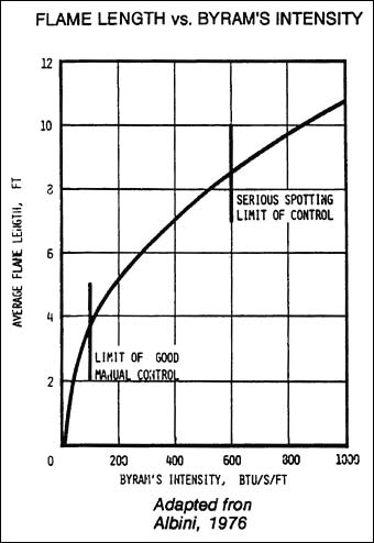
Fire Safe Plans developed within the I-Zone will be based upon Hazard Assessment. The critical components of the hazard being measured will be identified and, where appropriate, fuelbed modification prescriptions will be developed to mitigate those portions of the hazard deemed unacceptable. Defining the component parts of Hazard and how each part might be described and evaluated would include the following. The fuel complex volume and type can be represented by one of the stylized fuel models used for Fire Behavior or Fire Danger prediction. The National Fire Danger Rating System (NFDRS) fuel models are preferred over the Fire Behavior Prediction System (FBPS) models because they contain a large fuel (1000 Hour) component. The arrangement while a part of the Fuel Model description is further described by a measurement of fuelbed continuity without significant interruptions. The location is described by the steepness of the slope, the position on the slope (bottom, midslope or top), topographical features (e.g., rolling, broken, etc.) and proximity to other hazard areas. The condition is best described as a measure of fuel moisture. Dead fuel moistures are a function of weather conditions ( amount and duration of precipitation, days since precipitation, average temperature, relative humidity and wind direction, velocity and duration). Living fuel moistures are physiological responses of a plant to growth processes and available soil moisture although plants also respond to weather conditions, especially wind and temperature. Obviously, fuel moistures are only important at certain times of the year. Direct sampling over 10+ years show critical living fuel moistures are reached in chaparral fuels in late August to mid September. While similar measurements are few, it is likely that the same conditions exist in non-deciduous tree species. To be useful in hazard assessment, the weather conditions which result in critical dead (and live) fuel moistures, must be known. The National Weather Information Management System (WIMS) and Remote Automated Weather Stations (RAWS) data can be sorted through various programs to determine severe weather ( the 90th and 97th percentile) and the number of days per decade that critical fire weather occurs. The Fire Weather Severity Index (FWSI), developed by the Desert Research Institute in Reno, Nevada can also be used to determine the number of days of severe fire weather per decade. The ease of ignition can be described by the NFDRS Ignition Component or the FBPS Ignition Potential. The suppression difficulty can be predicted through the spread routines in the BEHAVE and FIRECAST fire behavior prediction programs, the relative ease of access and through the fire area / perimeter predictors and fireline construction and containment rates found in the Fireline Handbook (NWCG Handbook #3) and elsewhere or through the SIZE and CONTAIN options in the BEHAVE program. Process From the first attempt to quantify and describe hazard by Hornby in 1934 to the present, numerous techniques and guides have been developed. While the rate of spread component can be predicted rather accurately through the use of various fire behavior prediction systems based on Rothermel's Fire Model, difficulty still exists in uniformly and consistently predicting the difficulty of suppression element. Combining the two components into some sort of usable Hazard Rating has been achieved but has not been agreed upon by all users. While some fire managers with considerable experience can estimate hazard with fair accuracy, most cannot. In addition, estimates unsupported by data have little value in planning processes where alternatives are subjected to economic analysis. Much of the subjectivity of earlier processes has been removed in the following but experienced judgment is still required to "fine tune" some results. The following incorporates available information regarding severe fire behavior and attempts to quantify heretofore subjective estimates of slope and fire behavior on fireline construction and holding rates. The objective of the hazard assessment process is to enable planners to evaluate current and predicted conditions with a set of standard criteria and uniformly applied processes. The result will be a hazard appraisal which may not absolutely represent the real world, but which accurately reflects the relative rankings among fuel, topography and weather regimes. Calculating the Growth Potential Growth potential is the term used to describe the rate of spread which has been adjusted for severe fire behavior and for the first burning period or first run fire size. The nominal rate of spread is that rate of spread generated by a fire behavior processor such as BEHAVE, FIRECAST. Fire Behavior Nomograms or Fire Behavior Lookup Tables. By adjusting that nominal rate of spread we can calculate an effective rate of spread which will show the difference in hazard between extreme but short lived rates of spread on short, steep slopes under moderate burning conditions and similar but sustained fire spread on longer slopes or on gentler topography under severe burning conditions. Severe fire behavior is directly related to fireline intensity. The greater the intensity, the more likely the chance for torching, spotting, crowning, and other severe fire behavior phenomena, including increased spread, increased perimeter to contain, possible inability to protect all exposures and generally reduced suppression success. FIGURE 1 and FIGURE 2 show the relationships among intensity, flame length and fire behavior. For the Hazard Assessment needed to develop a Fire Safe Plan, the weather and fuel conditions used to calculate the Growth Potential should be those at the average worst or the 90th percentile. FIGURE 1
Since the fire model is intended to describe a flame front advancing steadily in contiguous, homogeneous surface fuels within 6 feet of, and contiguous to, the ground, the outputs must be adjusted to account for short range and long range firebrands which may be blown ahead of the flaming front where they ignite fuels and increase the rate of fire spread. The challenge, then, is to develop adjustment factors which approximate this increased spread under conditions which exceed an average flame length of 8 feet and Byram's Intensity exceeding 600 BTU/S/FT. TABLE 1 increases the nominal rate of spread of a head fire to reflect this increased spread caused by spotting. Flanking fires can accurately be represented by the fire model but backing fires cannot. It should be recognized that the TABLE 1 factors overpredict spread In Fuel Models 1 and 2 because firebrands are typically too small to ignite new fuels. It should also be noted that spotting can be predicted for some fuel models through the use of the BEHAVE subroutine SPOT. FIGURE 2 FIRE SUPPRESSION INTERPRETATIONS OF FIRELINE INTENSITY AND FLAME LENGTH
Adapted from "Help in Making Fuel Management Decisions"
Certain combinations of fuels, weather and topography have the potential to become large, damaging wildfires. Whether the size and damage potential is caused by high rates of growth and the inability to provide adequate resources for perimeter containment or high intensities which require more conservative tactical considerations such as flanking attacks rather than control efforts at the head of the fire, the Growth Potential and Damage Potential must be calculated. TABLE 1: GROWTH POTENTIAL
The first adjustment to the nominal rate of spread (obtained from your fire behavior processor) is to increase it to reflect the increased growth caused by spotting. To use the table, take the rate of spread (ROS) and the flame length from the fire behavior processor and jot them down. This is your nominal ROS. Take the flame length, lookup the adjustment factor in the GROWTH POTENTIAL TABLE and multiply that nominal ROS by that factor. EXAMPLE #1 : The nominal ROS is 8 chains per hour (ch/hr) and the flame length is 9 feet. From the table, you see that the adjustment factor for a 9 foot flame length is 1.5. 8 ch/hr X 1.5 = 12 ch/hr Your effective ROS is 1.5 times the Fire Model ROS because of spotting. Remember the table overpredicts in grasses and that SPOT can be used in some fuel models. The fire size and fire perimeter at this new growth rate can be found in BEHAVE subroutine SIZE and CONTAIN or in the Fireline Handbook Lookup Tables. Those combinations of fuels, weather and topography with the potential for large wildfires are, obviously, more hazardous with greater damage potential. As stated previously, in the same fuel type, using rate of spread alone, a fire originating at the bottom of a steep slope under moderate burning conditions would have the same rate of spread as a fire on more gentle topography under severe burning conditions. Rating the two fuel-weather-topography regimes using ROS alone would show they are equal but, in fact, we often contain the former at the ridge top (with spotfire complications) while the latter become much larger. The second adjustment to the rate of spread is to modify it to reflect the fact that the rate of spread is not sustained for long timeframes. In other words, 100 ch/hr for 20 minutes followed by 1 ch/hr for 40 minutes (the result of a slope or fuel model change) is an effective rate of spread of about 33 ch/hr. * Size without successful containment The next step to estimating Growth Potential is to estimate the probable fire size at containment, at the end of the first run or at the end of the first burning period. (Fire size can be estimated through the BEHAVE subroutines SIZE and CONTAIN or through the area / perimeter tables and fireline construction and containment rates found in the Fireline Handbook). Estimate the probable fire size, look up the adjustment factor in the Growth Potential Table corresponding to that acreage and multiply the rate of spread by that factor. EXAMPLE #2: The predicted rate of spread (ROS) is 42 ch/hr. The location of the fuelbed being analyzed is such that that rate of spread would drop radically because of topography (fire reaches a ridge top, fuel type change or other factor which reduces fire spread). The probable fire size at the end of the first run is estimated at 90 acres. The adjustment factor for a 90 acre fire is 0.4. 42 ch/hr X 0.4 = 16.8 (call it 17) ch/hr The effective rate of spread is only 40 % of the initial rate of spread because that rate of spread was not sustained. Obviously, if the site under analysis is within the originating rate of spread, access and response times for protection forces, clearance, fire resistant construction, etc. would be critical to the survival of those structures in the absence of defensible space measures. EXAMPLE #3: The predicted ROS is 11 ch/hr. Flame length is 9 ft. Estimated fire size at the end of the first run is 259 acres, 11 ch/hr X 1.5 = 16.5 ch/hr 16.5 ch/hr X 0.4 = 6.6 ch/hr The Growth Potential in this case is about 6 1/2 chains per hour. Additional adjustments could also be made for crownfire potential and for averaging the effects of two intermixed fuel models in a single fuelbed. Processes for calculating crownfire probabilities are attached as Appendix___. The process for using two fuel models is found In GTR INT-143. Calculating First Run Damage Potential Historically, damage potential was based upon fire size at containment and those resource values and improvements which were partially or totally consumed within the final perimeter. In the I-Zone, the-values-at risk are the structures and resource losses are typically given a low priority. While containing the perimeter is always a factor, protecting life and property is given the highest priority. First Run Damage Potential is important because it tells which properties are likely to survive (or not as the case may be) on their own before the situation can be assessed, suppression resources can arrive, be deployed and have an effect upon the protection of structures. Within the I-Zone, structures are ignited in one of three ways. The most common is the one easiest to recognize and protect against - firebrands falling upon flammable roofs, usually of wood shakes. Structures are lost both inside and outside the fire perimeter. Under severe conditions, structures have been ignited at distances of more than a mile from the flaming front by firebrands. In 1961, the Stanford Research Institute, in their post-fire analysis of the Bel Air Fire in Los Angeles County, found that more than half the 505 homes destroyed would have survived with fire resistant roofing and brush clearance. The second way is through either direct flame impingement or the concentration of convected heat under structures, decks, alcoves and eaves. Flame contact and convected heat also ignites structures when a firebrand Ignites leaves, litter or combustible materials such as firewood, patio furniture, etc. which has accumulated or is stored under one of these overhanging structures. Fuel modification for considerable distances on the downhill side of structures has been the typical way employed to eliminate ignitions from convected heat along with removal of combustible materials from under and around structures. The third way, understood but unquantified until recently, is ignition through radiation from burning vegetation.** Radiant heat often breaks windows or melts non-metallic screens covering building openings allowing radiated heat or firebrands to ignite the interior. Radiant heat often precludes the commitment of firefighting resources to a structure because their positions would be untenable. A vertical flame height of about 6 feet from burning low (18" tall) shrubs within 10 feet of a wood sided structure, for example, is not sufficient to ignite the structure but a firefighter will experience pain on exposed skin after about 5 seconds. (More later when we study the Structural Ignition Assessment Model) Significant structure losses typically include large numbers of simultaneously exposed structures, the rapid involvement of fire into residential areas, overwhelmed fire protection capabilities and the loss of fire suppression support infrastructure (e.g., loss of water supplies, traffic-clogged or otherwise blocked roads, etc.) The calculation of damage potential has several parts, and as we learned in Units #3 and #4, there are a number of factors to consider. Additionally, we must estimate the time (from ignition) of wildfire encounter with the structure(s) being evaluated and the fire characteristics at the time of encounter. ** Ignition of one structure from an adjacent, burning structure has been recognized for some time in ISO Ratings. The Uniform Building Code and Uniform Fire Code provide construction methods and materials to prevent such ignitions. In every I-Zone Fire Plan, the first consideration must be the safety of residents. This is especially critical in the area of the first run. The availability of adequate evacuation routes, fire apparatus ingress and egress, (road widths, roadside hazard reduction, the location and availability of safe haven areas, etc.) must be evaluated and documented. The second consideration is the protection of the structures themselves. Structure-to-structure ignitions are common with between-structure vegetation acting as a fuse carrying fire to new exposures. In all I-Zone Damage Potential assessments, the ability of structures to survive a wildfire encounter without the additional protection of fire fighting personnel and apparatus should be the goal since, as described above, fire protection capability may be overwhelmed and suppression support infrastructure may be compromised. It is important, therefore, that those structures likely to be jeopardized in the first run be identified. This can be done by using the area / perimeter calculations for the calculated Growth Potential to determine fire size and fire characteristics in hourly timeframes and the likely encounter with structures in those timeframes. Calculating the Suppression Difficulty Historically, Suppression Difficulty was called Resistance to Control. This was a measure of the difficulty of fireline construction and holding by hand crews dictated by rate of spread, fuel type and slope. Later, different crew types, dozers, engines and air tankers were added to published production rates. A set of production rate tables is attached as Appendix ____. In the I-zone, perimeter containment is important, not only to reduce fire size and resultant damage but also to prevent the involvement of additional structures. Under severe burning conditions, containment efforts may be ineffective at the head of the fire but flanking attacks may well decide the fate of structures not yet threatened. The critical Suppression Difficulty concern in the I-Zone is the ability to deploy suppression resources to protect structures. Questions to be answered include: What is the status of defensible space at the structures in jeopardy? It would be tempting at this point to try to develop a Suppression Difficulty
Rating Matrix. Unfortunately, this approach tends to aggregate elements rather than identifying specific
Resistance to Suppression elements, which could be mitigated or eliminated through appropriate measures.
|
|||||||||
|
|||||||||
|
Copyright © El Dorado County Fire Safe Council |
|||||||||